FOVICKS
Friends
Of
Vast
Industrial
Concrete
Kafkaesque
Structures
|
This is my photo journal of industrial photographs I've taken of
the Los Angeles River flood control channel.
As an amateur 'Industrial Archaeologist', I love the LA River as a bizarre
curiosity. Many groups have formed in attempt to
beautify or revert the "river" to a previous state. But I like it
the way it is; a weird, massive concrete flood control channel.
This unusual structure is testimony to the local geology, seasonal rains,
and the vast urbanization of the LA area.
It is mainly the urbanization in the 20's and 30's which
severely modified the drainage of the Los Angeles basin
and San Fernando Valley, creating the immediate need for the
necessarily large, ominous flood control system that we see today.
Before flood control, the deceptively quiescent river
transformed into a wild torrent during seasonal floods, and like a
renegade river, would jump its banks, carving out new random meandering
riverbeds throughout Los Angeles,
killing people, destroying highways, businesses, residences and livestock.
Also, the ability for the ground soil to
naturally absorb flood waters was decreased so dramatically due to the
urbanization of LA, that water runoff was increased to several times
that of the original natural flood levels. So much so, that at its mouth
in Long Beach, the LA River's flood waters were once measured to exceed
the normal flow of the Mississippi through St. Louis.
|
LA flood control is a complex system of hundreds of debris basins in the
surrounding canyons, secondary regulating dams, storm drains, paved control channels,
and specially constructed streets that act as secondary storm drains.
After decades of failed attempts using unpaved culverts, levees and the like,
the 'river' has finally been fully controlled by paving it all over with
portland cement. There simply is no going back to a dirt bottom river
without removing the town around it.
The river itself seems unnecessarily large to the casual onlooker,
as it always appears to be empty. The truth is, during floods it becomes
quite full, transforming into an enormous violent water highway.
When empty, it is a monument to its purpose; exposed raw civil
engineering for all to see, if one cares to look closely enough.
Hell, there are even
bike paths
around it now.
I like the LA River in its current state for the same reason I like
deserted airports, industrial plazas, railroad tracks, and other vast
structures that boldly stand for years on end in zen silence. Some people get
the same feeling standing in Joshua Tree State Park, at the Grand Canyon,
or atop the Empire State Building.
This photo sequence starts at the beginning of the LA River (in Calabasas)
and travels to its end in Long Beach.
| - |
 |
|
|
-- Work In Progress --
1-21
 The Start of the LA River
The damn thing officially starts here, where Arryo Calabasas(left)
meets Bell Creek (right), near the intersection of Basset and
Owensmouth, in Canoga Park.
Hope you weren't expecting forests and humming birds..
Looking West, this is the intersection of two creeks
that officially marks the beginning of "The LA River".
According to this,
the elevation of this area is about 795' above sea level.
Knowing the ocean to be approx. 50 miles (264000 feet) downstream,
assuming the grade were even, the average drop of the river bed would
be ~15.9 feet per mile. Given that, what's the grade angle?
Let's see, I haven't done trig in a while..
eh, "the SOHCAHTOA indians lived in right angle teepees",
so "Sine is Opposite over Hypotenuse", um..
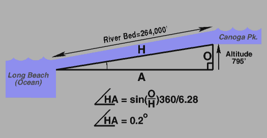
..an average grade of .2 degree (2/10ths of a degree), which doesn't
sound like much, but water doesn't need much of grade to move.
Try balancing a sheet of water on a pane of glass, and see how
close to 0 degrees you have to be to keep it from rapidly spilling..!
 1-22
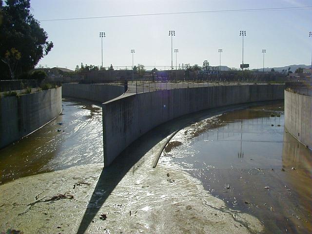
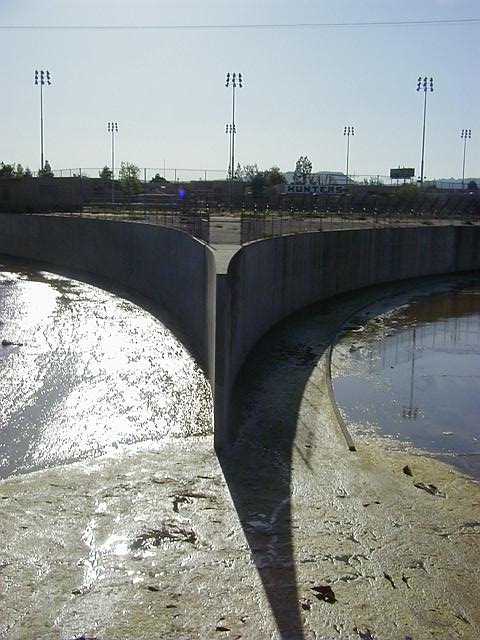
1-22
Extension Wall
Where the two 'creeks' meet, a very
conscious effort
was made to extend a common wall between the two rivers projecting downstream. This is the
prominent web-like projection in the above photo. This same design can be seen at other
points of confluence, where two rivers intersect. I believe the name for this is a 'training
wall', presumably to 'train' the currents of the two intersecting rivers so when they actually
meet, the flows are in parallel, preventing an "off-angle" flow turbulance that can cause waters
downstream to vault the nearby surrounding banks under high capacity flows.
During heavy floods, these rivers are designed to operate very close to full capacity (run
almost to the top), and water speeds increase dramatically as the water runs down from the
canyons. These web like constructions prevent large wakes from forming where the two
currents join. In my experience, when two currents join, if they are at even subtle angles
to each other, they cause cross-currents that create large diagonal wakes that can vault
up and over the opposite banks. This could then carve away and undermine the dirt behind
the river walls, causing structural failure of the walls, and the flood water currents can then
carve away the structure, and meander into the streets causing destruction similar to the 1938
floods that wrecked many parts of the city.
 1-23
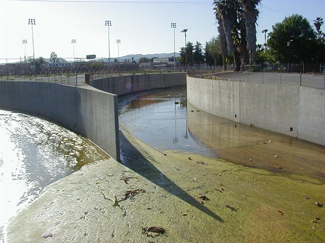
1-23
Large amounts of moss and sediment build up, probably due
to the fact that here, neither creek has a 'slot' to channel
the water to move it more quickly. So it lays flat and stagnates.
The Bell Creek (right) has a small 'guide' which attempts to channel the water
along the western wall, but if that's its intent, it doesn't seem to be working
well.
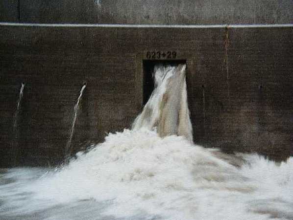
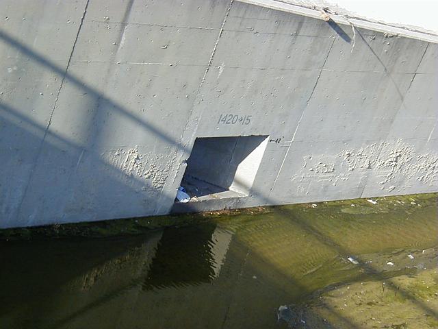 1-24
1-24
Sewer Outlet with surveyor's distance marker
The "1420+15" distance marker written in stencil above sewer outlet near
Calabasas/Bell merge shows it's 142015 feet (almost 30 miles) from here to
the downstream northeast corner of Griffith Park, where the river makes a 90
degree turn south to the ocean as it meets the Verdugo Wash. Another 30 miles
south, the river finally ends in Long Beach harbor at Terminal Island.
During floods, the paved sections of the LA River can move water
at speeds as high as 45 miles per hour.
 1-25
1-25
 1-rou
1-rou
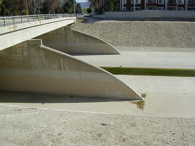
LA River, upstream side of Reseda overpass supports, facing south.
Water flows to the left (east). Note tapered stanchions on the side
facing oncoming water. Presumably tapering allows the speeding oncoming water
more time to displace around the supports, reducing backflow, vertical wake,
and overall wear on the concrete supports from floating debris
(which would slide along the tapers, rather than crash headlong
into strictly vertical supports).
From what I've seen, when large items like tree limbs or telephone poles
float along in flood waters cross-wise, they hit these tapered edges, causing the item
to slide along onto it, and "see-saw" such that one side of the item ends up in the air,
the other in the current, causing the current to pull and re-orient the item length-wise
so the current can then pull it under the bridge so it can float on through, avoiding
the creation of a cross-wise debris-dam.
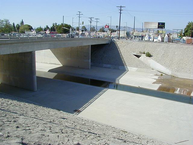 1-rod
1-rod
LA River, downstream side of same overpass, looking north.
Supports on the downstream side are simple vertical sections.
Imagine if this were the upstream side, and a floating
telephone pole were to crash into these vertical supports,
the concrete would take the full brunt of the force, possibly
cracking it, leading to a failure of the bridge's supports.
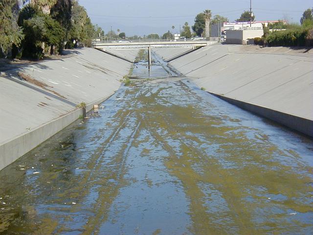
1-03
View from Reseda overpass looking downstream (east).
Reseda Recreation Area above right.
Birds are attracted to stagnating water (center/left)
as it travels across the sloping riverbed
from the sewer outlets to the central 'slot'.
The river bed here is solid and smooth, but "V" shaped walls
are made from a rough cement-and-stone composite, giving
it the appearance of 'dirt' (extreme right). Not sure
if the intention here was intentionally a cosmetic one,
or simply lack of time/budget, or practical for easy walking
down the banks without slipping. My guess is the latter.
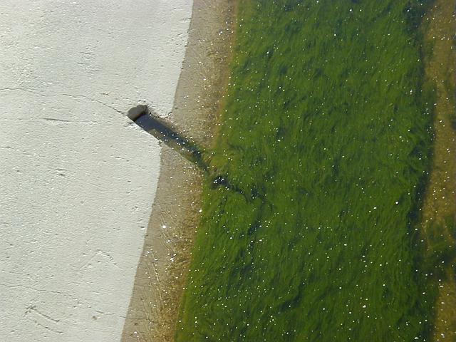 1-05
1-05
Close up of 'slot'. Water appears clean. This hairy
plantlife is found throughout the river.
Not sure what the small downstream-facing diagonal groove is.
A few inches in width, and mirrored on either side of the slot,
these groves repeat every 50 feet or so at this section of the river.
 1-07
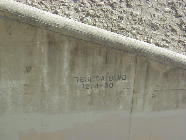
1-07
Close up of one of the Reseda overpass supports.
Rough river wall of composite material can be seen in
upper right. Rounded top of support shows striation,
revealing construction technique.
The "1214+80" is a surveyor's mark indicating this section is
121480 feet
(1214 x 100 + 80 = 121400 + 80 = 121480)
from some point downstream, probably where the river ends, or where it
joins into a larger river.
These marks are posted all along the river walls of the entire
LA flood control system, the two numbers together indicating a
'station number' ("twelve fourteen plus eighty"), a common surveyor
notation. These numbers are used for linear measurements along
civil works projects such as pipelines and highways which can be
curved; the numbers mark linear coordinates along the project's
'Baseline' (which runs down the center of the project), a referent
for all elements along its length.
These numbers appear directly above storm drains, in the center
of overpasses, or in some places, every ~500 feet along the bare
walls (eg. 300+0, 305+00). The right hand number is always two
digits, 00-99.
Sometimes there are decimal numbers, eg. "300+20.50", where the
.50 means 6 inches, the fractional part of a foot.
At times I've seen things like: "115+20 o/s -30", where "o/s" means
"offset", and the number that follows being a left/right position
*perpendicular* to the baseline in the horizontal dimension;
+ being right of center, - being left of center. So in the case
of the LA River, that number would mean a point 11520 feet upstream
from the 0+00 mark, and a position 30 feet to the left of the center
of the river looking upstream, such as a position on the left wall.
 1-08
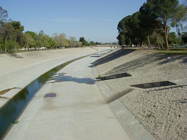
1-08
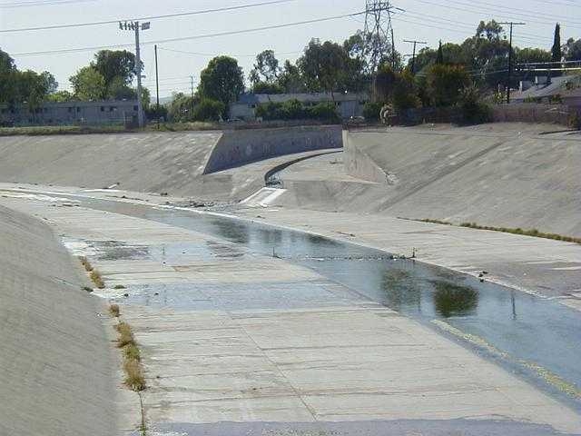
Aliso Canyon Wash / LA River merge.
Near Yolanda and Haynes, Reseda.
Taken from a pedestrian bridge (next photo).
The intersection of the two rivers is graphically
quite literal; the Aliso river cross-section is exactly
cleaved by the sloping wall of the LAR. Cool, visually.
The Aliso is slotted too, with a strict rectangular
cross section as opposed to the LAR's "V" slot.
The Aliso, a significantly smaller 'wash', enters the
middle of the river wall, presumably to prevent backflow.
Surprisingly, the Aliso doesn't just get deeper as it approaches
the river, simplifying vehicle access between the beds.
If you look closely, you can see they went out of their way
to put vehicle ramps on either side of the slot
to allow vehicle access between the two rivers.
Back to my home page.
All images on this page © Copyright 2000 Greg Ercolano. All rights reserved.
|
